Whole-site First-assessment Toolkit for combined Mineral Resource and Archaeological assessment in Sand and Gravel deposit (FASTRAC)
2007-2008
Participants
University of Leicester (lead site): Ian Hill (PI), Kip Jeffrey, Lex Comber, David York
University of Birmingham: Keith Challis, Chris Carey
University of Nottingham: Lee Elliot, David Knight, Katy Mee, Gary Priestnall
British Geological Survey: Barry Smith, David Jones, Anthony Morigi, Mike Raines, Sarah Nice
English Heritage: Neil Linford
Geomatrix Earth Science: Chris Leech
Lafarge Aggregates: Kirk Blackburn, Gareth Burdell, Duncan Wardrop
Funding
English Heritage
Project Overview
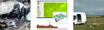
The main aim of this project is to create an evidence base to demonstrate the advantages of integration of first-assessment ground investigations for both Mineral Assessment and Archaeological Evaluation, using a combination of rapid survey methods. Developing technology is producing novel, precise, densely sampled data through airborne survey (notably LIDAR and hyper-spectral methods) and ground-based follow-up using a multi-sensor geophysical survey platform. The advantage of this approach is the ability to cover large areas and assess the different data sets rapidly, providing information early in the development cycle to mitigate the impact of mineral extraction on the historic environment. Furthermore, the project will demonstrate that the detailed early assessment of a site allows issues such as geodiversity, habitat, maintenance of soil function, flood risk, and groundwater resource, to be addressed in a development project in the interests of both local authority and developer.
Geographical Information Systems will be used to integrate disparate data sets and to develop novel ways to visualise data in combination to reveal patterns and correlations relating to potentially significant sub-surface arfifacts. The role of Nottingham in the project is to lead on the archaeological interpretation of one case study site in the Trent valley (Trent and Peak Archaeology) underpinned by the GIS-based exploratory visualisation (School of Geography).
The potential outcomes of the project are:
- Better-informed decisions being made by all parties (industry, heritage, planning) at less cost to each participant.
- Less disagreement between archaeologists and geologists since both will be using the same data.
- Reduced need for invasive ground investigation (e.g. trenching, drilling), allowing archaeologists and geologists to concentrate on areas of significant interest.
Research Outcomes
Related Links
School of Geology, University of Leicester
Trent and Peak Archaeology, University of Nottingham
The Institute of Archaeology and Antiquity, University of Birmingham
British Geological Survey
|