Channel Adjustment on the River Bollin
1994 - 1997
Principal Investigators
Pete Downs
Gary Priestnall
Funding
The University of Nottingham New Lecturers Grant (Pete Downs)
Project Overview
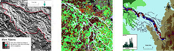
| This project focussed on a watershed analysis for the Bollin river (right), an English lowland catchment with a great heterogeneity of land use types and histories, and without direct coupling of hillslope and channel processes. In this analysis, identifying the dominant process regimes (the initial stratification) became a central question. The project developed a model structure that focused directly upon the river channel, asking questions about its ability to adjust its form according to in-channel, riparian and catchment conditions. As expected, the discriminator of stream power (as energy available to do work) is, per se, insufficient to distinguish types of channel adjustments observed using field survey. In this setting, process dominance within the channel cannot be stratified without knowledge of human activities in the catchment and model development requires that human impacts are accommodated according to their process implications. |
View Larger Map |
The aims of the project were:
- To account for river channel adjustments along the river Bollin
- Apply existing lumped regression model
- Experiment with different spatial units
- Use GIS for data storage, parameter estimation, and display
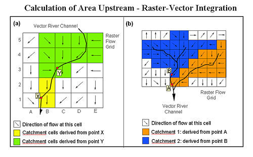
At the time most GIS-based analyses of river catchments used raster (grid) based techniques, however it was felt that the importance of the river channel network itself meant such data models did not offer ideal data representation where, for example several model parameters related to the shape and slope of the river network. Priestnall and Downs (1996) summarised an approach to developing a hybrid raster-vector model to offer the 'best of both worlds' in terms of GIS-based representation. It allowed intergrated parameter estimation using data layers representated as either raster or vector as apporpriate, based within the Laser-Scan LAMPS 2 mapping environment but using bespoke functions written in C code, spawned from LAMPS 2 macros. The diagram below illustrates what at the time was considered a unique approach to calculating upstream area from a point using the upstream vector river network to avoid the inclusion of rogue catchments (catchment 1 in figure (b)) as would occur with conventional raster tecyhniques. Even burning the vector river into the terrain model would not cope in situations where multiple river lines occupied a single cell of a terrain model.
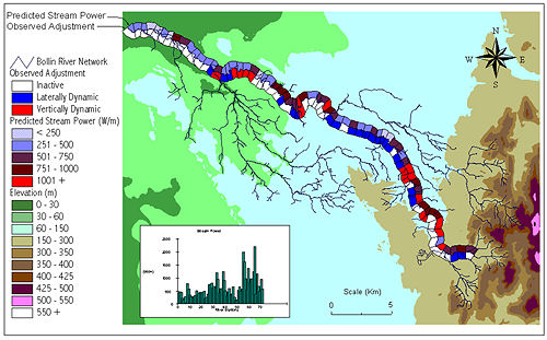
Visualisation of model results occured within the GIS/mapping system as below, showing predicted stream power mapped against observed adjustment at regular stages or reaches down the main Bollin river channel. This gave an indication of the spatial distribution of model success and formed part of a cyclic process of model refinement.
Research Outcomes
Downs, P. W. and Priestnall, G (2003) Modelling fluvial geomorphological processes at the catchment-scale in Kondolf.M and Piegay.H (eds) Tools in Fluvial Geomorphology Wiley, 205 – 230
Downs P.W. and Priestnall G. (1999) System design for catchment-scale approaches to studying river channel adjustments using a GIS, International Journal of Geographical Information Science, 1999, 13, 3, 247-266 1365-881
Priestnall, G. and Downs, P. W. (1996) Automated parameter estimation for catchment scale river channel studies: the benefits of raster-vector integration, Proceedings of HydroGIS 96: Application of Geographic Information Systems in Hydrology and Water Resources, Vienna, Austria, April 1996, IAHS Press, Institute of Hydrology, Wallingford, UK pp 215 - 233
Related Links |