
Gary Priestnall
School of Geography ,
The University of Nottingham,
University Park,
Nottingham, NG7 2RD
Email: gary.priestnall@nottingham.ac.uk
A lecturer
in Geographical Information Science in the School of Geography, The
University of Nottingham. Research draws upon a background in Physical
Geography, Art, Computer Science and more recently Geographical Information
Systems (GIS). Pattern recognition in maps, satellite imagery and LiDAR
digital surface models has been an ongoing area of interest. Landscape
visualisation and GIS have been combined with studies recreating past,
present and future landscapes for Environmental Impact Assessment and
in the creation of interactive CD-ROMs to convey landscape change. The
combined use of computer visualisation, GIS and community art has provided
fascinating and rewarding opportunities recently. Notions of representation
are being explored both in terms of effective visualisation of urban
environments and movements within these environments, and also exploring
engaging and intuitive forms of representation for use in consultation
exercises.
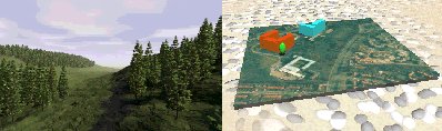
Landscape Visualisation: Natural and urban, photorealistic and abstract
Back to Hawley Square Exhibition
For further information about this project or web site contact: Gary.Priestnall@nottingham.ac.uk
www.mappingchange.com