
Paul Aplin
School of Geography ,
The University of Nottingham,
University Park,
Nottingham, NG7 2RD
Email: paul.aplin@nottingham.ac.uk
A lecturer
in Geographical Information Science (GIS) with interests in remote sensing,
GIS and geostatistics, and their application to physical geography.
Research interests include: Land cover classification; Fine spatial
resolution satellite sensor imagery; Integration of remote sensing and
GIS; Synthetic Aperture Radar (SAR) analysis; Spatial scale of land
cover. A fellow of The Royal Geographical Society, member of The Remote
Sensing Society and a member of the American Society for Photogrammetry
and Remote Sensing.
Research Projects include:
- Vegetation classification in southern africa using multiscale remote sensing (2001-2003) Funded by the Nuffield Foundation
- Combining interferometry and per-field classification for temperate land cover monitoring (2000-2003) Funded by the National Space Development Agency of Japan
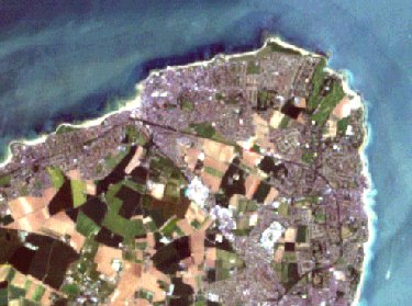
Landsat image of Margate
(resolution reduced for display on web)
Back to Hawley Square Exhibition
For further information about this project or web site contact: Gary.Priestnall@nottingham.ac.uk
www.mappingchange.com