A sophisticated, digital three-dimensional model of Nottingham has been acquired by City as Lab, bringing with it a range of exciting opportunities for research and development.
The interactive model – known as a 3D “mesh” - is made up of many thousands of high-resolution photographs of Nottingham taken from the air, which have been stitched together to form a seamless, detailed map of the area.
Whilst primarily created as part of the University of Nottingham’s support for a city council project to better engage citizens in planning processes, the 3D mesh could be used for a wide range of other purposes now and in the future.
The 3D mesh allows for detailed exploration of the city, effectively enabling the viewer to take a virtual tour of Nottingham and see its buildings and topography in stunning detail. It puts the viewer in the driving seat and in control of a rich and immersive experience.
The mesh model came about as part of City as Lab’s involvement in a successful Nottingham City Council bid for funding to explore 3D technologies as a way to modernise the planning application process. The Council secured a £375,000 grant from the Department for Levelling Up, Housing and Communities (DLUHC), which will be spent on enhancing a cutting-edge system to map the city in three dimensions. This will improve the planning process as applicants, planning officers, councillors and the public will be able to view accurate, real-life images of how a proposed development will look within the existing built environment.
City as Lab is already supporting this project by adding to the suite of 3D technologies the City Council will use, including new use applications and adaptions of the University’s innovative Projection Augmented Relief Model (PARM). The PARM is a three-dimensional model, which can be adapted in a variety of ways through the overhead projection of map-based data. The 3D mesh is the next evolution of City of Lab’s involvement.
Dr Jasper Donelan, Digital Research Specialist for City as Lab, took up the story: “Nottingham City Council are exploring a variety of options that could make up a suite of 3D mapping tools and, as part of our discussions, they expressed an interest in obtaining a high-resolution 3D photographic mesh. At City as Lab, we realised this would have significant potential beyond just the city council project, so we agreed to co-fund the creation of this model.”
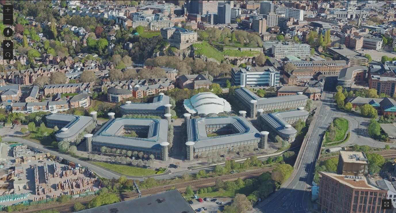 A screenshot taken from within the 3D mesh model shows an aerial view of Nottingham in stunning detail
The 3D mesh was created by the aerial survey company Bluesky. To capture the images required, the company flew an aeroplane over Nottingham on two dates in April and May 2023, using sophisticated photographic and scanning equipment to take over 6000 ultra hi-resolution, orthorectified aerial photographs. This bank of detailed images was supplemented with data captured via "Laser Imaging, Detection, and Ranging" (LIDAR), which allows for accurate representation of elevation and range. This moves the map from being a flat, two-dimensional rendering into an accurate, three-dimensional model of the area.
The resulting 3D mesh is an impressive virtual rendering of Nottingham’s architecture, infrastructure and open spaces. Jasper continued: “There are only a handful of cities that have this level of detailed and accurate modelling, so Nottingham is leading the way in this exciting space. As well as using the 3D mesh to support the city council, we think it presents a wealth of other exciting opportunities. For example, the model could be used to overlay data for research purposes, to explore the optimum positioning of solar panels or green roof gardens, or as a virtual flyover for use in promoting the city. These are just a tiny proportion of the ideas for potential use. As part of the City as Lab initiative, we will be interested to hear from others on how they might like to explore using the model and the underlying data to solve local challenges in the city and region.”
Do you have a use for this digital asset? Get in touch