An innovative piece of technology that brings maps and models to life in new and exciting visual ways is one of the impressive projects benefitting from Digital Nottingham’s involvement.
The Projection Augmented Relief Model – or “PARM” – is a three-dimensional model, which can be adapted in a variety of ways through the overhead projection of map-based data. By overlaying a physical model of an area in this manner, a range of scenarios can be explored at the press of a button – with endless possibilities for research, data exploration, local authority planning and more.
The PARM technology means that a physical model can effectively be changed and adapted to demonstrate whatever data one wishes. For example, the PARM could be used to show the parts of an area that are most at risk of flooding from a local river, in the event of heavy rainfall. It could be used to chart the gradual growth and development of a city’s infrastructure over time. Or it could bring to life survey data, for example, illustrating different people’s perceptions of what constitutes their local “city centre” or showing which pubs are most frequently visited by respondents.
In its physical form, a typical PARM display comprises a highly detailed 3D-printed model of a landscape created from digital terrain data, much of which has been captured using airborne laser scanning. The model is laid flat, usually at tabletop height, and a projector is positioned above it. The projector is then configured to project maps, images and animations directly onto the model to demonstrate different scenarios. The images are generated within a Geographical Information System (GIS) then warped to fit the model perfectly when projected. The result is a fascinating way to explore and visualise different scenarios, that is significantly more engaging and interactive than merely looking at a static map or model.
Gary Priestnall, Associate Professor from the University of Nottingham’s School of Geography, is leading the PARM project. Its development stemmed from a collaboration between Dr Priestnall and artist Jeremy Gardiner, when the pair worked together in 2011 on a research project at the University of Nottingham.
Gary said: “Physical models have been used for hundreds of years for military planning and to help visitors understand unfamiliar landscapes. They let people study detail but also take in an overview of a landscape in a very natural way, without them having to interpret a map.”
“Traditionally these models would have been painted to represent natural landscape colours, but today, with digital projection, we can recolour the models dynamically to bring them to life. We can create sequences of projected overlays that help tell a story about landscape, or to help communicate complex patterns across space and over time. These overlays can be projected using a normal PowerPoint show, to allow easy editing of the content at any point, often by the host organisation.”
“Using 3D printing we can create very detailed models which, when illuminated through projection, can create an engaging holographic effect. This can help draw people to a display but also hold their attention, making it more likely they will focus on the content of the presentation. Many PARMs to date have been small portable rigs that can be used in school sessions, museums, visitor centres, or tourist information centres."
Dr Priestnall explained how using the PARM could revolutionise the way in which geographic information can be represented. He said: “In public settings, a map on a wall is a common way of showing the location of something, or the distribution of related items, but this can be limited when it comes to representing different interrelated themes in space and through time. Animated maps on screens can help here but they still require people to interpret the information quickly. By using a physical model, which is closer to our everyday view of the world, PARM offers a way to present geographic information in a form that is more accessible and engaging for public audiences.
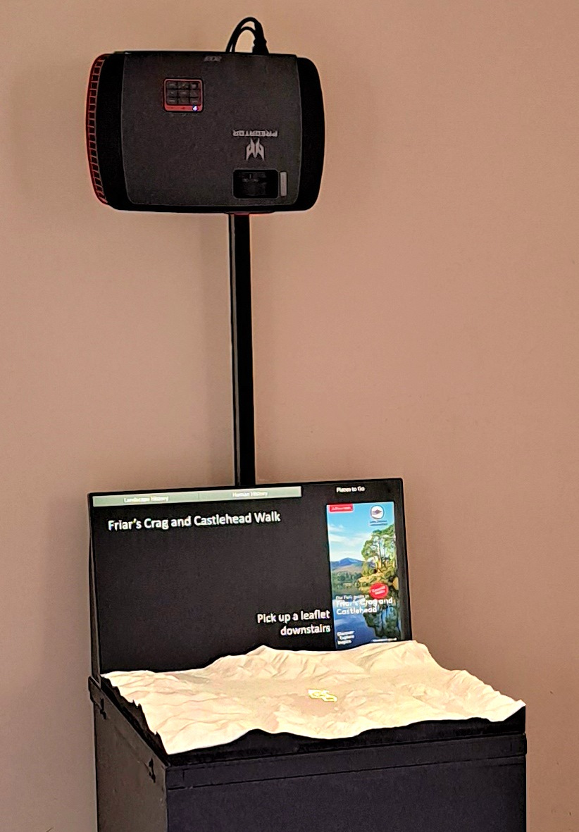
A basic PARM setup, at Keswick Tourist Information Centre in Cumbria.
The first public PARM display was at the Wordsworth Trust Gallery in Grasmere, Cumbria (2012-2013) focussing on key landscape references in William Wordsworth’s poem ‘The Prelude’. These early explorations with PARM in England’s Lake District led to Dr Priestnall creating an exhibition of both historical and modern landscape modelling techniques called ‘Grandest Views’ at Keswick Museum in 2015. It was the development of a PARM for use in Keswick School soon afterwards that led to a requirement for flood data and a collaboration with a company called JBA Consulting, who undertake flood modelling for the Environment Agency. JBA were able to generate flood depth maps at regular intervals through a flood event for many different scenarios of flooding. Several PARM-based flood risk demonstrators followed before Dr Priestnall and JBA co-designed a display for use by the Environment Agency for public consultation in Hebden Bridge, West Yorkshire.
With the support of Digital Nottingham there is now the opportunity to enhance the capabilities of PARM and explore its use in relation to a wider range of local issues. The Digital Nottingham team has funded the creation of two displays based on Nottingham; one focussed on the city centre, and one on the wider city. The use of a touchscreen interface allows many alternative maps to be projected onto the model at will, allowing viewers to explore the city through data. More specific versions of the general ‘city explorer’ displays are now being developed which focus on themes such as accessibility to greenspace, or planning.
In addition, the Digital Nottingham team has provided time and expertise to make further enhancements to the original PARM. Not only is it being made easier for other researchers to import their own data into the system, but the system itself is being enhanced. Developments have begun using Unity, a cross-platform game engine which can be used to create interactive simulations as well as 3D and 2D games.
Gary said: “The use of game engine technology will allow us to create simulations of flooding or crowd movements and create dynamic lighting effects. It also opens up the possibility of having Virtual Reality experiences linked into the PARM display, driven from the same game engine, allowing us to explore how the capabilities of these two technologies might work together.”
And what does the future for PARM hold? In addition to further improvements to the technology, Gary sees significant potential for its use in a wider civic setting: “The application of PARM is only limited by our imagination. We have seen it work well in museums and visitor centres, and in formal education, but I think it has great potential as a tool to engage local people in a variety of ways. For example, local authorities could use it as a planning tool to promote discussions with citizens about their local environment, to visualise new uses of existing parks or public spaces, or to assess the likely impacts of changes to traffic flows.”
Indeed, the Digital Nottingham team recently lent its support to a Nottingham City Council application for a £375,000 Government grant to further improve 3D technology to modernise the planning application process. The money, which has come from the Department for Levelling Up, Housing and Communities (DLUHC), will be spent on enhancing a cutting-edge system to map the city in three dimensions, and is part of a national £3.2m scheme through the PropTech Innovation Fund involving 27 local planning authorities. The funding was given the green light in late March and will be used to develop a suite of 3D tools to improve the planning process as applicants, planning officers, councillors and the public will be able to see how a proposed development will look within the existing built environment. PARM will be central to these developments with a larger fixed display being co-developed with Nottingham City Council, to be located in the Digital Nottingham space within the new Castle Meadow Campus close to Nottingham City Centre.
Gary said: “There are so many exciting prospects for the technology. I am delighted the Digital Nottingham team are supporting us in taking PARM to the next level and we look forward to exploring new ways to put it to use in the city.”
Do you have a use for this digital asset? Get in touch