Gary
Priestnall [Profile]
Theme: 3D Model
![]()
Brightness, Texture,
Elevation
Digital Image on paper
The production of a 3D model within the context of Geographical Information Science usually involves using ground elevation as the third dimension. Objects such as buildings can be constructed within a digital model from architectural information to create realistic 3D worlds which can reproduce past, present or future scenes from within the urban environment. Alternatively stereo photographs or satellite images can be used to automatically derive digital surface models of both the ground and the objects on the surface.
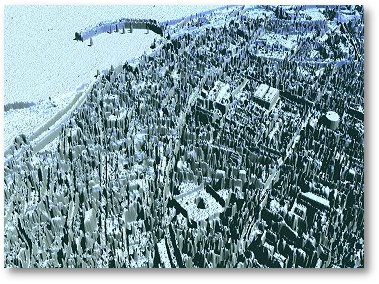
The image displayed is a perspective view of a computer generated 3D model of Margate but in this case the model is an unconventional one. The third dimension is neither ground elevation nor the true elevation of buildings derived by any kind of stereo photography or other survey techniques. In this case the vertical dimension is brightness, taken from a black and white aerial photograph. Objects which appear high in the image to the right were bright in the photograph, whereas troughs or low points were very dark in the photograph.
The image offers an alternative representation of the texture which appeared in the photograph. Linear features such as dark roads bounded by bright pavements appear as walled canyons. The diamond shaped path in Hawley Square stands above the darker grass which surrounds it. Waves breaking on the beach and boats in the harbour appear white in the photograph and therefore elevated in the perspective view of the model.


A sequence of images displayed in the gallery illustrated the transition from photograph to the extruded view we see above
Back to Hawley Square Exhibition
For further information about this project or web site contact: Gary.Priestnall@nottingham.ac.uk