
Theme: Land Cover
![]()
Land Cover Classification
Digital Image on paper
From a geographical perspective, land cover is the description of the
physical nature of the land surface, for example, vegetation, buildings,
water or bare soil. Commonly, the only affordable means of mapping land
cover is through ‘remote sensing’, the practise of deriving
information about the Earth’s surface from overhead images. In
this demonstration, ‘land cover classification’ has been performed
using a satellite image and an aerial photograph of Margate.
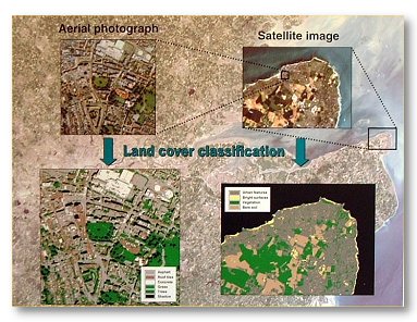
The background to the display is a regional ‘Landsat’ satellite image of south-eastern England. This image has a ‘spatial resolution’ of 30 m, meaning that only features larger than this size, such as agricultural fields, can be clearly identified. This is demonstrated by the inset satellite image, an enlargement of the Landsat image centred on Margate. Here, small urban features such as buildings and roads are not easily distinguished. Consequently, land cover classification, the process of categorising images according to distinct land cover classes, is necessarily general. For example, only a single ‘urban’ class is identifiable, instead of different classes for specific urban features, such as asphalt (for roads) and roof tiles (for buildings).
The aerial photograph centred on Hawley Square is far more detailed than the satellite image, with a spatial resolution of around 1 m. This means that small urban features like houses, gardens and roads can be identified. This is demonstrated by the land cover classification that enables the distinction between specific urban feature classes, including asphalt, concrete and roof tiles.
Back to Hawley Square Exhibition
For further information about this project or web site contact: Gary.Priestnall@nottingham.ac.uk