


Mobile Learning
Context-Specific Visualisation
This project aimed to engage student groups in certain technical debates concerning the nature, and use of digital surface models, photography and digital reconstructions of glacial landscapes. Students need to acquire an understanding of the differences between a real environment and a computer simulation of that environment. They should be aware of the data utilised in building a computer model of a landscape, and the inaccuracies therein. For example the resolution of elevation data, mis-representations of vegetation, or the age of overlaid photography may paint a false picture of the true current landform.
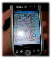
A simple augmented reality technique using perspective views printed on transparencies has been used successfully over a number of years. The students would print views of a computer model onto paper or transparancies to compare them in the field with the real world views. The focus of this SPLINT application was to extend and update this existing project, by using GPS-enabled Personal Digital Assistants (PDAs). An application was coded to allow a PDA to deliver the spatially referenced 3D views of hidden landscapes (geology) and past landscapes (glaciated) in the context of a physical geography fieldtrip.
During development of this application, a technique for synchronising user location between lab-based real-time stereo visualisations and the PDA applications (via bluetooth) was utilised to assist with application development. Walking up a hillside in the visualisation theatre, would send out strings via bluetooth simulating the data a GPS would receive in the field, allowing a PDA to show location dependent information.
One of the groups of students on the undergraduate field course in March 2007 were given a SPLINT video camera to record a video diary of their experiences on the Context-Specific Visulisation day. A short sample of this video will hopefully be made available soon.
Publicity Materials
Download a printable leaflet (.pdf) about this research [here]