A Sense of Place
Maps, illustrations, photographs and written descriptions all help to build up an idea of how a place has changed over time. Collections at the University include original archival items relating to communities in the midlands, to other parts of the British Isles, and to far-flung corners of the world.
Many of the finest and most detailed maps are found in estate collections. Early estate maps, now rare, were created by surveyors for large landowners to help manage the property. In the absence of alternative records, they can provide important evidence of land use, waterways and roads or paths. Estate records of land transfer also list field and street names, and can show how property boundaries were established.
The experience of travel to distant places is found in correspondence and diaries. Those who went abroad on business or who emigrated sent home accounts of their new surroundings. Young men from wealthy families who went on the Grand Tour or travelled on military or government service left documents and pictures in their family archives.
These records supplement the extensive published resources in the East Midlands Collection and the Special Collections. Publishers in the eighteenth and nineteenth centuries satisfied a popular demand for works of topography and travel, in the shape both of practical gazetteers and accounts of the latest explorations overseas. Such descriptions of foreign places are often coloured by the writer's own prejudices, making them relevant sources for the history of ideas as well as the history of the places in question.
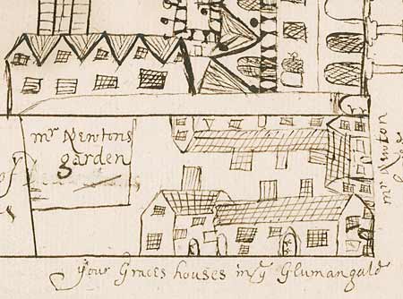
Detail from a plan of Chesterfield, Derbyshire, c.1668 [Pl E12/16/4/3/31]
Detailed plans of towns are rare before the mid-eighteenth century. This example is particularly interesting because the buildings are shown pictorially, and the names of occupiers are given. It was drawn in connection with a legal case concerning a right of way from Glumangate, and was found in the archives of the Dukes of Portland’s London solicitors.
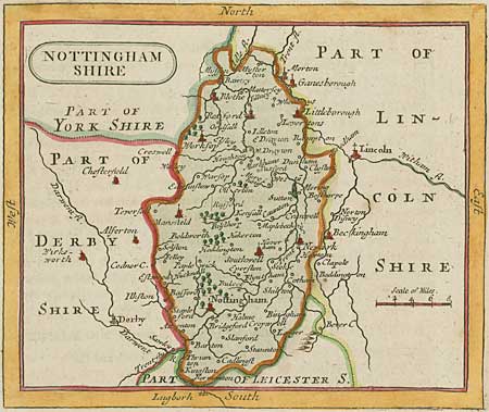
Printed map of Nottinghamshire by John Seller (fl.1658-1701), 1777-1787 [Bre 15]
Until the Ordnance Survey maps of the early nineteenth century, most county maps provided few details about roads or the relative size of different towns and villages. Because of their rarity and their visual quality, early printed maps are now often found detached from bindings. This reprint of Seller’s Nottinghamshire, first published in Anglia Contracta (1695), comes from Francis Grose’s Supplement to the Antiquities of England and Wales (London, 1777-1787).
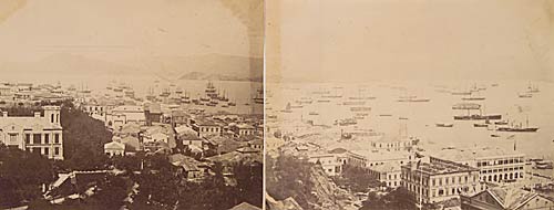
Photograph of Hong Kong Harbour, c.1860 [Ne C 11,121]
Photography is an excellent medium for capturing a sense of place and showing how places change over time. This is strikingly illustrated by the early view of the town of Victoria, with its low-rise buildings and prospect of the western entrance of Hong Kong harbour. It was taken by Felice Beato (c.1833-1907?). The original print survives in the archive of the 5th Duke of Newcastle, who was Colonial Secretary from 1852 to 1864.
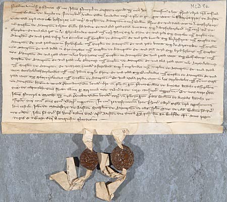
Gift of land in Beeston from John and Matilda Poutrel to William de Amyas, 1341 [Mi D 84]
Medieval title deeds are important sources for the local historian, providing details about street and field names, and sometimes naming the owners of adjacent properties. They are in Latin, and their use is assisted by detailed cataloguing.
This example describes parts of the fields and meadows of Beeston. Among the place names still recognizable 650 years later are Derby Street [Derby Street or Road], Brodegate [Broadgate] and Schortylandes [Rylands].
Half an acre in Halfacres; 1 rood in Langforland; one and a half roods abutting Langorlangherd; 1 rood in Le Schynbandes; 1 rood at Stepowe; 1 rood at Les Combes; 1 rood abutting Derby Strete; 1 rood in Nybbesdale; 1 rood abutting Brodegate; 1 rood in Crownrodes; half an acre at Brokfurlong; 1 rood in Les Brerrodes; 1 rood at Wolfwong; 1 rood in le Oldemor; 1 rood in le Brodeholdmor; 1 rood called Astortland at Longlondes; 1 rood Atte Holehalfacrehendes; 1 rood at Wetelandes; 1 rood at Schortrylandes and 1 dole of meadow lying in Les Acrelandoles.
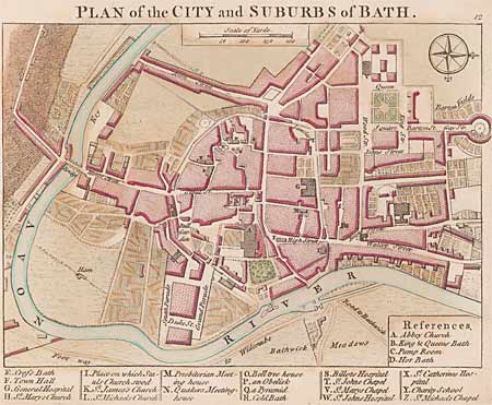
Plan of Bath, from A collection of plans of the principal cities, of Great Britain and Ireland…, drawn from the most accurate surveys, in particular, those taken by the late Mr. J. Rocque, topographer to His Majesty (London, 1764) [Spec. Coll. G1814.A1 COL]
One of 23 maps and 18 plans published by A. Dury in a volume designed to accompany his Universal Pocket Atlas.
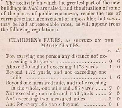
Detail of a page from John Feltham, A guide to all the watering and sea-bathing places: with a description of the Lakes, a sketch of a tour in Wales, and itineraries: illustrated with maps and views (London, 1806) [Spec. Coll. DA665.F4]
‘Tourism’ by members of the aristocracy and gentry increased massively in the eighteenth and early nineteenth centuries. Better roads enabled faster and more comfortable travel. Feltham’s work anticipates the modern ‘Lonely Planet’ or ‘Rough Guide’ approach, providing practical details of facilities − such as the rates payable to ‘chairmen’ (carriers of sedan chairs) − alongside illustrations and descriptions of the resorts.
Next: Messages in different Media