Enclosing Laxton
‘Enclosure’ was the process of fencing open fields and common land and extinguishing communal grazing rights over those lands. Farmers in open fields had to work the fields co-operatively, but farmers with enclosed land could cultivate it exactly as they wished and fully exploit new machinery and farming techniques. Laxton still has open fields and common land, but it is a mistake to think that Laxton was never enclosed. In fact, enclosure processes have been going on for hundreds of years, and have shaped how the village looks today.
Moorhouse was enclosed under the terms of the General Inclosure Act of 1845. The Moorhouse Enclosure Act was passed in 1849 but the award was not completed until 1860. The process of enclosure was expensive, because new fences and hedges had to be built, drainage improved, and new roads created. The Thoresby estate accounts reveal that the enclosure of Moorhouse cost £1,427 12s 5d.
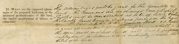
Detail from application form addressed to the Inclosure Commissioners, c.1847
From Manvers Collection Ma B 215/65
This form gave the Inclosure Commissioners information relevant to the proposed enclosure of Moorhouse. It included this paragraph listing the expected advantages:
The advantages will be great for the quantity of land. The Commons are undrained, covered with Thistles and so over stocked as to be of little value. The Arable land being in scattered pieces in the several open Fields subject to the Common Stock is Farmed to great disadvantage. The improvement both to the Open and inclosed land will lead to profitable employment for Labourers and materially increase the value of the land.
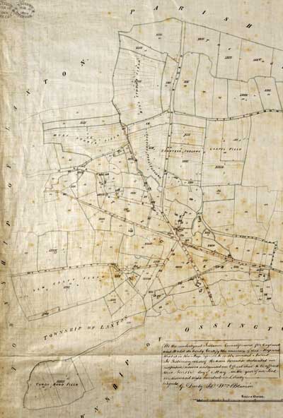
Plan of Moorhouse, 1820
From Manvers Collection Ma 5415
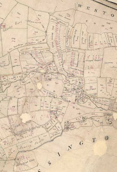
Moorhouse enclosure plan, 1860
From Manvers Collection Ma 2P 100
These plan details show that the open fields in Moorhouse, although very much smaller in overall size than those in Laxton, were also made up of narrow strips arranged into furlongs. After enclosure, the area which had been open field was divided into separate allotments. The plan shows that strips previously held by a variety of people were now held as consolidated pieces of land. New roads were also constructed across what had been open field.
Click here to see a fuller version
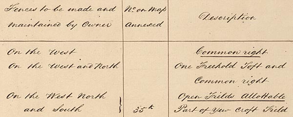
Detail from Moorhouse enclosure award, 1860
From Manvers Collection Ma 2P 100
This detail shows some of the pieces of land allotted to John Barlow, shown in Roman numerals on the map. He was allotted three in respect of the strips he had held in the open fields, and two in compensation for his common right (his right to graze his livestock on the common, which was now enclosed). His “old inclosures” were unaffected by the process. He had to fence his new allotments, at his own expense.
Laxton itself never went through formal enclosure, thanks to a combination of factors including the existence of many freeholders owning small pieces of land, and the unwillingness of successive Earls Manvers to bring it about. Most of the freeholders had sold out to Earl Manvers by the early twentieth century. Between 1903 and 1908 his agent, R.W. Wordsworth, made radical changes to the open fields. Enclosure reduced the total area by almost half. The remaining strips were consolidated in order to try to get each tenant’s land into single blocks, reducing the number from 1162 to 263. According to John Beckett (A History of Laxton, 1989), this process provided “many of the benefits of enclosure without incurring the full cost.”
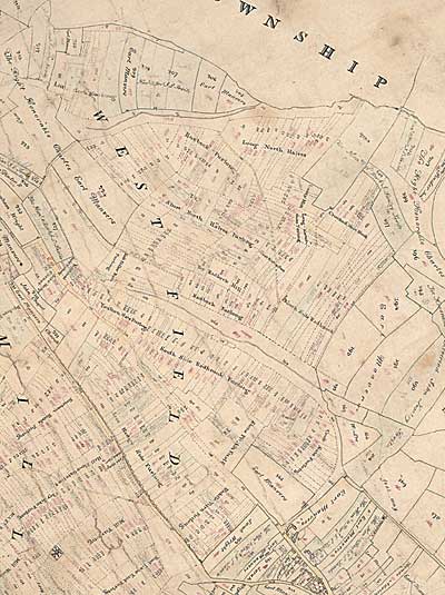
Plan of the West Field, 1820
From Manvers Collection Ma 5415
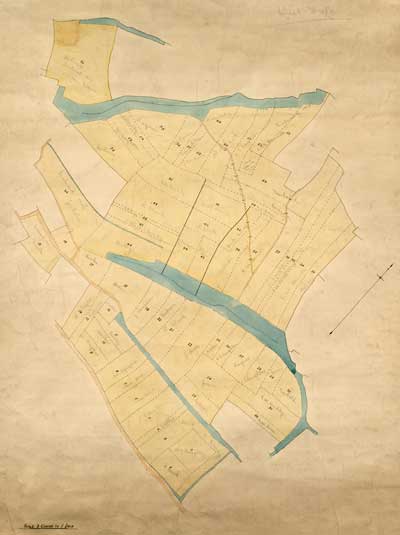
Plan of the West Field, 1906
From Manvers Collection Ma 5431
In 1820 the West Field (called Top Field by Laxton farmers) was a patchwork of narrow strips. Groups of strips were arranged into furlongs, each of which had a name. Furlongs were oriented along the lie of the land so that excess water could drain off down a slope. After the re-organisation by R.W. Wordsworth, the West Field attained its current shape. Narrow strips were amalgamated to form strips wide enough to admit more modern farm machinery. Named furlongs disappeared, although most strips still follow the traditional orientation.
More: Living and Working in Laxton
Laxton: Farming in an Open Field Village home