Mapping Residential Expansion
The most concentrated period of residential development in the Park followed the appointment of the architect T C Hine as surveyor in 1854. Prior to that, building had largely been confined to the Park edges - Park Row, the Ropewalk, Park Valley, Park Terrace, Derby Terrace and so on.
The University holds plans which illustrate the development of the estate in the twenty years from 1880 to 1900. At the first date, Hine's 'dumb-bell' design had already been well established, though open spaces are were still available on Clumber Crescent and Tattershall Drive, and Cavendish Road East did not yet exist. There had been little development at the south end of the estate, where the River Leen could still be seen running alongside the canal.
In contrast, by the later date, Hine's layout was virtually complete, with far fewer empty plots. Lenton Boulevard had been built; the southern area had been developed for residential use; and both the River Leen and the Duke's Wharves had gone.
The density of the residential development is clear from these plans.
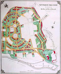
Nottingham Park Estate 1880
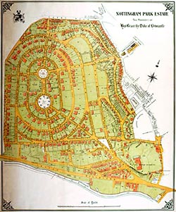
Nottingham Park Estate 1900
More: Speculations and Proposals
Nottingham Park: From Ducal Estate to Urban Residence home