Types of Maps and Plans
As might be expected, there are numerous different types of maps and plans. The main types to be found within manuscript and archive collections are:
Ordnance Survey Maps: the Ordnance Survey was the first comprehensive mapping project undertaken in Britain. The resulting printed maps were published by the Crown and are in four main groups - the one inch; the six inch; the 'town scales'; and the 1:2500 maps. The earliest one inch map was published in 1801, and the six inch series appeared during the mid-nineteenth century.
Tithe Maps: these show the plots of lands which were liable to pay tithes to ecclesiastical parishes. After the 1836 Tithe Act, tithes were commuted by the government into a simple tithe rentcharge. Tithe apportionments (listing landowners, tenants, properties, acreages and amount of tithe payable), with accompanying maps were created for 75 percent of the parishes in England and Wales.
Enclosure Maps: these were produced in association with enclosure awards, by which open fields or wastes or commons were converted to individual, private plots of land. Before 1845 enclosure was managed at a local level; after that time it was overseen by a central government department. Enclosure maps usually show the different areas of land owned or leased by individuals after an enclosure award was made.
This example is a map of North Muskham in Nottinghamshire, created two years after enclosure and showing the new fields and their owners.
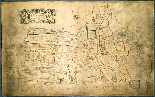
Map of the townships of North Muskham, Holme and Bathley, Nottinghamshire; 1773 [Ne 6 P 3/25/1]
Manorial Maps and Plans: these were created from the sixteenth century onwards, at the instigation of manorial lords who employed surveyors and cartographers to make maps of their lands, with particular emphasis on the bounds of the manor.
Estate Maps and Plans: these illustrate estates owned by prominent local landowners - both private and institutional. Some maps may show all of a particular landowner's holdings; others may show all their property in a specific town or village. There may also be site plans of particular estate streets or buildings - or parts thereof. Estate maps may sometimes be accompanied by terriers - a written survey or list of lands and property belonging to an estate.
Here is a plan (pre-1768) showing land in Newark Fields, Nottinghamshire, belonging to the Earl of Lincoln.
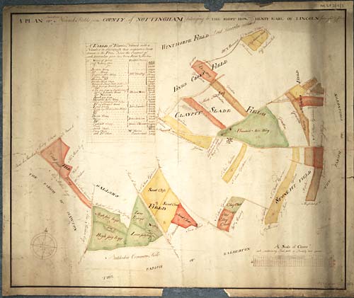
Plan of fields in Newark, Nottinghamshire, as surveyed by J Crow c.1768 [Ne 6 P 3/15/3]
Town and County Maps: these began to be produced in great numbers after the introduction of printing. They were much in demand at times of rapid development and were often produced in series by cartographers such as Christopher Saxton, John Norden, William Smith and John Speed.
This County map of Nottinghamshire was a reprint of one drawn by Richard Blome (d 1605)
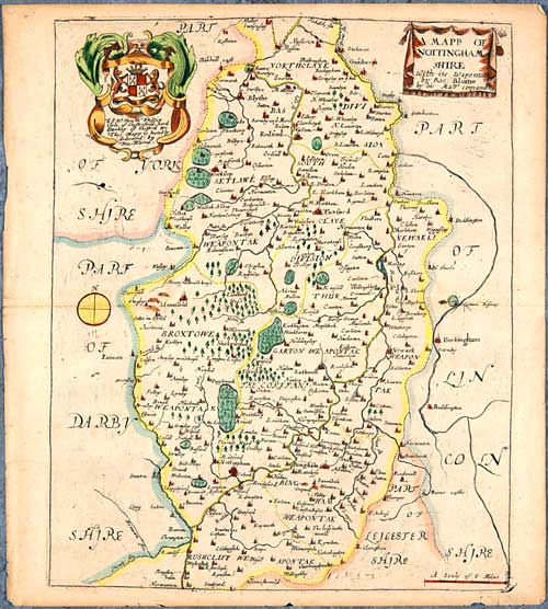
County Map of Nottinghamshire by Richard Blome (d 1605), published in 'Britannia: or, a Geographical Description of ... London' (1673) [Bre 5]
Canal and Railway Plans: with the wave of canal and railway building which swept across Britain, numerous maps and plans were produced. They may have been made as part of feasibility surveys for determining the most suitable route of the canal or railway, to help facilitate working once building schemes were underway, to accompany compulsory purchase orders, or to aid construction and maintenance.
This is a plan of the intended canal from Cromford to Langley Bridge in Derbyshire and Nottinghamshire, produced in 1789.
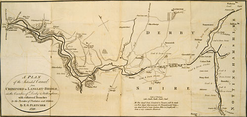
Plan of the intended canal from Cromford to Langley Bridge, Derbyshire and Nottinghamshire [Pl E12/11/16/1]
Military/Naval Maps and Plans: these may have been of particular geographical locations, or of particular military and naval formations; they provided the information required to enable troop/ship movement and subsistence, or to illustrate points of strategy in particular campaigns.
Here we have a plan of Trèves [Trier], made during the conflict there in 1675.
![Pw A 2058 - Plan [of Trèves]; n.d. [c. 1675], with letters indicating the position of French troops](/ManuscriptsandSpecialCollections/Images-Multimedia/ResearchGuidance/MapsandPlans/05-1191m.jpg)
Plan [of Trèves]; n.d. [c. 1675], with letters indicating the position of French troops [Pw A 2058]
Maps and plans also survive as part of other types of archival document. Within deeds, for example, it is very common to find a map or plan - perhaps drawn into the margin, on the reverse, or attached in one corner. These may indicate the bounds of a property, the whereabouts of geographical or topographical features mentioned in the deed, or may show the elevations of a particular building.
Sale catalogues, like this one relating to the Manor of Newark, are also likely to have detailed maps and plans accompanying them, as are fire insurance documents.
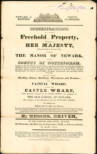
Plan from sale catalogue [Ne 6 M 1/3/2/3/3]
Next page: Skills required to interpret maps and plans