Nottingham Geospatial Institute

Public engagement activities

Maze for the public

It gives us great pleasure when we are asked to show, demonstrate and talk about the technologies that we use every day. We have some very advanced facilities, some of which are unique in the UK. These enable an increasingly diverse range of tasks to be undertaken. The techniques we use range from the simple, such as cameras, to the complex, such as advanced satellite positioning simulators. They now pervade the modern public, business and scientific worlds.
Professor Stuart Marsh

We exhibit at public events, give invited talks to societies and interest groups, and particpate in local and public projects such as the:

stuart marsh_2


Recent public engagement projects

Monks praying in a maze, image credit The Paul Nix Collection


Recreating the Shepherd's Race - a medieval turf maze

Based on an ancient drawing, NGI helps set out the shape of a modern rendition of an ancient maze, on grassland close to its original site, in St Anns, Nottingham [2014].

The idea to recreate the maze originated with Mo Cooper, of  St Anns Allotments.  The aim is to preserve the maze and its history, adding historical importance and pride of ownership to the local community. 

Until now, the only reference to its existence in Nottingham, is a garage located on the Wells Road called the Shepherd’s Race. But, if that garage disappeared there would be nothing left to hint at the existence of an ancient maze in the area.

Recreating the maze

An ancient maze has been recreated in the St Anns area of Nottingham. Strictly though, this is a labyrinth, not designed in the modern sense as a puzzle with dead ends, but rather as a continuous convoluted route, for meditation as well as enjoyment, being popular at country fairs.


ancient maze design with proposed modern version overlaid

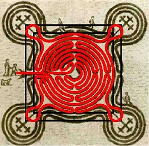
The image of a labyrinth ca.550AD, with the proposed
modern rendition overlaid [Image credit The Paul Nix Collection]

NGI's Lukasz Bonenberg volunteered to help recreate the maze, work which involved the creation of a digital model based on a surviving drawing, above; scaling and adjustment of this design to fit into the space currently available; and supervising the setting out process as carried out by volunteers unfamiliar with total station technology.


setting out the new maze

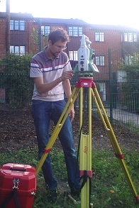
 Total station in action setting out the new maze

the completed maze

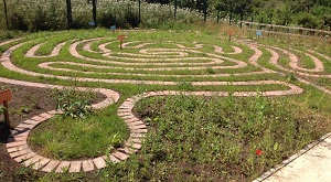
The completed maze, with two less bastions than planned,
owing to space constraints [Image credit Mo Cooper]

View the Nottingham Hidden History Team's article for additional information


Hemlock Stone, image credit Garth Newton


Unlocking the secrets of the Hemlock Stone

Multiple laser scan views made by NGI of the Hemlock Stone, a sandstone pillar in Bramcote Hills Park, Nottingham, are to be used to create a digital model to look for evidence of ancient tool marking [2013].

Read more oin the BBC website


 3 stones project logo

The Three Stones Project

A non-commercial project, led by Nottingham Hidden History Team's Director Frank Earp, is to be founded on 3D laser scans of each of 3 historically important stones.  The work, carried out by NGI, is intended to be the largest data gathering exercise ever attempted at these sites [2012].

Nottinghamshire has three large natural geological features. The Hemlock Stone at BramcoteThe Alter or Druid Stone at Blidworth and Bob’s Rock in Stapleford.

Read more about the Nottingham Hidden History Team  


Nottingham Geospatial Institute

Nottingham Geospatial Building
The University of Nottingham
Triumph Road
Nottingham, NG7 2TU

telephone:+44 (0)115 95 13880
fax:+44(0) 115 95 13881
email: Email Us