Hatfield Chase Corporation, 1538-1973
History
Origins, 1626-1629
The Hatfield Chase Corporation was an independent drainage authority covering parts of South Yorkshire, North Nottinghamshire and Lincolnshire.
The origins of the Corporation can be traced back to 1626, when King Charles I granted the Level of Hatfield Chase to a Dutch engineer called Cornelius Vermuyden (1590-1677). Hatfield Chase was a marshy, low-lying area which often flooded, and Vermuyden was asked to drain the area and reclaim the land. The newly-drained land was then to be divided into three parts: Vermuyden was to receive one-third, the Crown one-third, and the remaining third was to be divided among existing tenants who claimed right of Common over the Chase.
Work on draining the Chase began almost immediately and was finished within two years, at a cost of around £400,000. Drainage was achieved by straightening some rivers and diverting others into new drains. Among the improvements made were the following:
- The old River Idle was blocked at a place from then on called 'Idlestop'. Its waters were diverted into the River Trent along the Bycar Dyke.
- The eastern branch of the River Don above Thorne was blocked, and its waters diverted through another branch into the River Aire. Banks were built to prevent flooding.
- The southern arm of the River Torne was blocked. The course of the other arm was straightened by cutting a drain, and its waters emptied through a sluice into the River Trent at Althorpe.
- A second long drain was cut from Idlestop to Dirtness. This ran parallel to the Torne River and the water was sluiced into the River Trent at Althorpe.
- A third drain was cut from near Hatfield through Tudworth to Dirtness and then to the River Trent at Althorpe.
- The southern portion of the Isle of Axholme was drained by deepening and straightening the existing Snow Sewer.
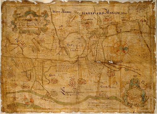
Coloured plan of Hatfield Chase, surveyed by Josias Aerlebout, 1639, showing the lands allotted to six Participants [HCC 9044]
The drainage scheme was funded by the sale of Vermuyden's land to a number of partners, known as Participants. Most of the earliest Participants were Dutch. The land owned by the Participants was called Scotted Land and was subject to the payment of scots, or taxes, to pay for the maintenance of the drainage works and any improvements subsequently carried out.
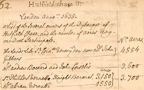
List of Participants in 1635 [HCC 9111/1]
In 1629, a Court of Sewers for the Level of Hatfield Chase was established by Royal Warrant. Commissioners of Sewers were empowered to hold courts to oversee all issues relating to waterworks and drainage in their area, and were responsible for assessing and collecting the scots, employing engineers, and taking measures against Participants who did not comply with their orders. New Commissioners of Sewers for the Level of Hatfield Chase were appointed at various times up to 1858.
Unrest in the 17th-18th centuries
Many local people were very unhappy with the effects of the Hatfield Chase drainage scheme. Some of the work was apparently not up to the standard required to cope with wet weather. Rivers overflowed and caused flooding in areas which had previously escaped winter inundations. People entitled to common rights, mostly from the neighbouring Isle of Axholme, were also furious, alleging that they had been allotted the worst land on the Chase. The Commoners brought various petitions and lawsuits against the Participants from the 1630s onwards.
The people of the Isle of Axholme took advantage of the confused situation of the Civil War and Interregnum in the 1640s and 1650s to take revenge on the Participants. They deliberately flooded Hatfield Chase by raising the floodgates of the Snow Sewer in 1643, and destroyed sluices and banks. It took until the 1650s, and the appointment of an agent called Nathaniel Reading, for the unrest to die down. In the 1680s, the Participants leased the manor of Epworth to Nathaniel Reading, which led to more riots. It was not until 1719, when the Commoners' latest Bill against the Participants was dismissed, that unrest around Hatfield Chase finally ceased.
In the meantime, one legal case was settled by a decree dated 20 February 1692/3. This divided certain pieces of land between the Participants and the petitioners. Certain pieces of land in the parishes of Belton, Epworth, Haxey and Owston (known from then on as Decreed Lands) were granted to trustees for the Participants. The rents and profits of these properties were applied to the maintenance of the drainage works, and helped to reduce the scots charged on the Participants' Scotted Lands.
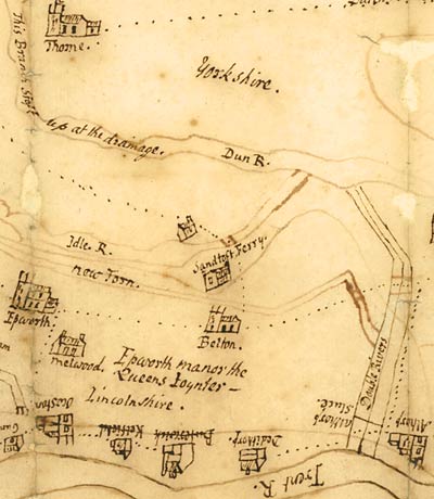
Map of the Levels, c.1700, with pictorial depictions of villages [HCC 9045]
Improvements up to 1862
Improvements to the drainage at Hatfield Chase were ordered by the Court of Sewers as soon as it was established, to complete the work started by Vermuyden. The wide 'Dutch River', near Goole, was created in the later seventeenth century when two parallel drains were swept into one by a great flood. However, most Court of Sewers business in the early eighteenth century was concerned only with maintenance of the existing system.
In 1776, the Carrs of Misterton, Everton, Gringley-on-the-Hill and Walkeringham on the southern side of the Chase were enclosed, and new drains were cut. Various Acts of Parliament were obtained in the late eighteenth and early nineteenth century to improve drainage in the area. The main Act was the Hatfield Chase Drainage Act 1813, its full title being 'An Act for the more effectually draining and improving Lands within the Level of Hatfield Chace, and Parts adjacent, in the Counties of York, Lincoln and Nottingham'. This Act gave power to appoint two Commissioners to put into effect specified drainage improvement schemes at a cost of £15,000. The works were to be paid for by assessments on the Participants' lands over and above existing scots. The Commissioners of Sewers were to retain responsibility for existing drainage works, and were to take over the new works once they were completed. Under the 1813 Act, a steam engine was erected in the south district of the Level to assist in pumping water. This was paid for by special engine-rates.
One of the advantages of cutting drains was that it allowed warping to take place. Warp (silty, earthy matter carried by rivers or tides) improves the fertility of soil. Warping is the process of deliberately flooding land in order to deposit layers of warp. Warping had always taken place on the Level of Hatfield Chase, but in 1854 an Act of Parliament was obtained, An Act to Warp and Improve Certain Lands in the Level of Hatfield Chase, which established the Hatfield Chase Warping and Improvement Company. The Company was empowered to purchase the Snow Sewer from the Participants and to use it as a warping drain to compulsarily warp certain adjoining lands. The Warping Company went out of business in 1916.
The Hatfield Chase Corporation, 1862-1941
The 1813 Act of Parliament had helped to improve drainage in the Level of Hatfield Chase, but the Participants wished to do more, including erecting a steam engine to drain the north district of the Level. They also wanted to extend the financial liability for these works to other landowners and ratepayers in the Level who benefited from the improvements. Accordingly, in 1862, an Act of Parliament to Incorporate the Participants of the Level of Hatfield Chase was passed, 'to incorporate the Participants of the Level of Hatfield Chase; to authorize the Construction of additional Works of Drainage in the said Level; and to subject certain Lands therein to Taxation'.
The Corporation of the Level of Hatfield Chase therefore replaced the Participants' governance of the drainage area. Nine Commissioners were elected to run the concern. Six were elected by the Participants, and three by landowners in the drainage area who did not own Scotted Lands (who had not previously been liable to fund the drainage). The Participants were still compelled to pay scots, engine rates and other rates. The tenants of unscotted land paid rates, but not scots. The area liable to pay rates to the Corporation was defined in the 1862 Act as the townships or parishes of Crowle, Wroot, Misson, Haxey, Epworth, Owston, Althorpe, Belton, Keadby, Armthorpe, Cantley, Auckley, Finningley, Rossington, Hatfield, Blaxton, Stainforth, South Bramwith, Fishlake, Sykehouse and Thorne - a far greater area than that covered by the Scotted Lands or Decreed Lands.
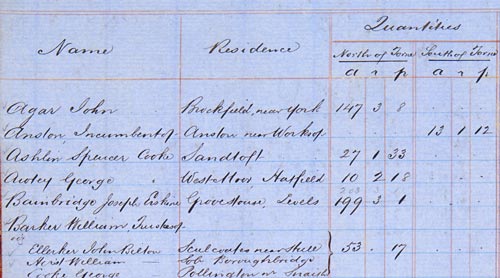
Extract from page from Register of Participants, 1862 [HCC 6052]
The last Commission of Sewers was granted in 1858. In 1862 the Court was replaced by the meetings of the Corporation. At some point before 1941 the area became an Internal Drainage Board for the purposes of administration.
In 1941, the 'powers, duties, liabilities, obligations and property' of the Corporation were transferred to the Trent River Catchment Board and the River Ouse (Yorkshire) Catchment Board by Statutory Order under section 11 of the Land Drainage Act 1930. The last meeting held under the old arrangements took place on 18 February 1941.
History of the authority after 1941
The drainage area of Hatfield Chase in fact continued to be run in much the same way as before. Records from 1941 to 1973 refer to the Trent River Catchment Board (later the Trent River Board, and later still the Trent River Authority) acting as the Corporation of the Level of Hatfield Chase for the area under its control. However, there was no longer an actual Corporation - it existed in name only. In 1974, responsibility for the drainage area was transferred to the new Severn Trent Water Authority.
However, the Corporation of the Level of Hatfield Chase was reconstituted as an independent body in 1987 by an order from the Ministry of Agriculture, Fisheries and Food: The Severn-Trent Water Authority (Reconstitution of the Corporation of the Level of Hatfield Chase) Order 1987. This provided for 'the reconstitution of the Corporation of the Level of Hatfield Chase acting under and by virtue of an Act of Parliament of 1813 and the Level of Hatfield Chase Act 1862 (c.cx1) and for vesting in the reconstituted board the property and liabilities of the Severn-Trent Water Authority so far as vested in or incurred by them in their capacity as the drainage board for that district.'
The Corporation of the Level of Hatfield Chase Internal Drainage Board operated under the terms of the Land Drainage Act 1991 and was responsible for maintaining water levels in its area and preventing flooding by use of pumping stations and watercourses. In April 2012 it was amalgamated with various other IDBs into the new Doncaster East Internal Drainage Board.
Records
The records of the Hatfield Chase Corporation were transferred to the University Library by the Trent River Board in 1951 and numbered HCC. A subsequent transfer was made in 1975 by the newly formed Severn Trent Water Authority. The records in this accrual have been given the reference R/HCC.
Multi-level descriptions of the Hatfield Chase Corporation records are available through the Manuscripts Online Catalogue.
The bulk of the records date from 1626 to 1943. Earlier records (which date back to 1538) are present as copies or extracts. The collection is made up of a vast number of records of the Court and the Corporation detailing all aspects of their work. There are basic administrative documents including minute books, Orders of the court, accounts and vouchers, lists of Participants and other ratepayers, correspondence, minutes and reports, and a sizeable body of conveyances, leases and other material relating to the properties owned by the Corporation. Later legal papers include records of litigation. A significant part of the documentation relates to the dealings of the Corporation with railway and mining companies, and there are papers concerning various Acts of Parliament.
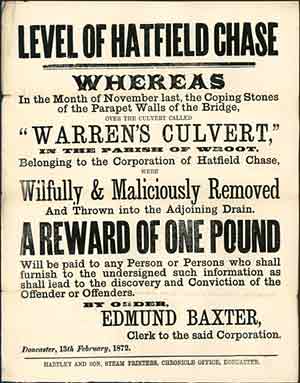
Handbill offering reward for catching people responsible for throwing coping-stones from a bridge, 1872
[HCC 6285/2]
There is a section of maps and plans (1639-1956) showing the area of Hatfield Chase. Some early deeds (1626-1692) include copies of agreements between Charles I and Cornelius Vermuyden regarding the drainage of Hatfield Chase, as well as abstracts of the Hatfield Manorial Court Rolls from the 14th century. Of particular historical interest is George Stovin's manuscript volume (c.1761) giving a brief account of the drainage of Hatfield Chase. This includes an extract from the Sandtoft parish register (now destroyed) listing the names of Flemish and Dutch immigrants who settled there in the 17th century.
The second deposit of records (R/HCC) includes files and papers dated up to 1973, recording the work of the Trent River Catchment Board, the Trent River Board, and the Trent River Authority acting as the Corporation of the Level of Hatfield Chase.
A related collection is MS 179 (catalogue record), which consists of papers concerning the environmental protection of Thorne Moor on Hatfield Chase, assembled by William Bunting from 1969-1970.
Next page: Brigg Court of Lincolnshire Commissioners of Sewers, 1725-1940