
| Home | The Team | Images | Methods/Fieldwork |
|
|
Palaeoenvironment of the Valsequillo Basin, Mexico | |||
|
| Basin Images | |||
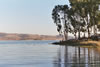
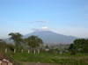 Valsequillo basin |
 Valsequillo basin |
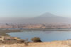 Valsequillo basin. A reservoir now occupies the lower areas of the lake basin |
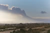 Valsequillo basin, Popocatépetl volcano erupting 10th January 2005 |
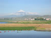
 Valsequillo basin, and reservoir, Popocatépetl volcano in the distance |
 Other archaeological sites in the Valsequillo basin include Hueyatlaco, which is currently submerged under the Valsequillo reservoir. |
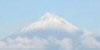 Popocatépetl volcano . |
|
| Site Images | |||
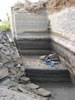
 The Xalnene ash covers older lake sediments. |
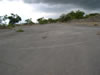
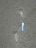 Footprints preserved in Xalnene ash |
 Close to the Cerro Toluquilla (volcano) the ash is around 5 metres thick, but the ash layer thins rapidly to 10 cm within 4 km north west of the Cerro Toluquilla |
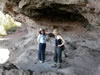 Rock shelter overlooking Valsequillo basin. Several early Holocene human skeletons were buried in the rock shelter |
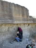
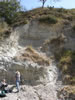
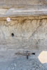
 General view of quarry showing ash layer where footprints are preserved |
 Xalnene ash, covered by lake sediments |
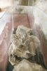 Mastodon skull found in the Valsequillo basin. |
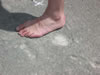 Footprint preserved in xalnene ash. Human foot for scale. |
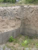
 The Barranca Caulapan. Alluvial sequences rich in fossilised bones. |
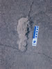 Footprint preserved in Xalnene ash. |
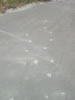 Footprints preserved in volcanic ash |
 Close to the Cerro Toluquilla (volcano) the ash is around 5 metres thick, but the ash layer thins rapidly to 10 cm within 4 km north west of the Cerro Toluquilla |
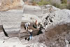 Local workers quarrying the xalnene ash for use as a building material |
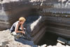
 The Xalnene ash covers older lake sediments. The circular hole is where samples for OSL (Optical Stimulated Luminescence) dating were taken by Dr. Jean Luc Schwenninger (University of Oxford) |
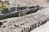 Locals now use the Xalnene ash as a building material, much in the same way as paving stones |
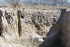 Xalnene ash, covered by lake sediments |
| Lab Images | |||
 Fluorination line, used for oxygen isotope extraction from diatom silica |
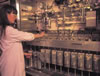
 Samples being loaded into Isotope Ratio Mass Spectrometer (IRMS) at the NERC Isotope Geosciences Laboratory. |
 Carbonate line, for preparation of carbonates for carbon and oxygen isotope analyses |
 Equilibration device for oxygen isotope analysis of water |
 One of the several Isotope Ratio Mass Spectrometers (IRMS) at the NERC isotope geosciences laboratories. |
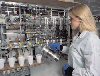
 Samples are weighed for isotopic analysis |
||
| University of Nottingham | Home • The Team • Images • Methods/Fieldwork |